LiDAR 3D Scanning: Understanding Its Role in Modern Construction and Building Projects
By providing a method for recording existing site and building conditions, LiDAR technology may support planning, documentation, and information management activities across a range of project types.
Digital technologies continue to influence the construction and building industry across Australia. Access to reliable site information is often an important consideration during planning, design, construction, and asset management activities.
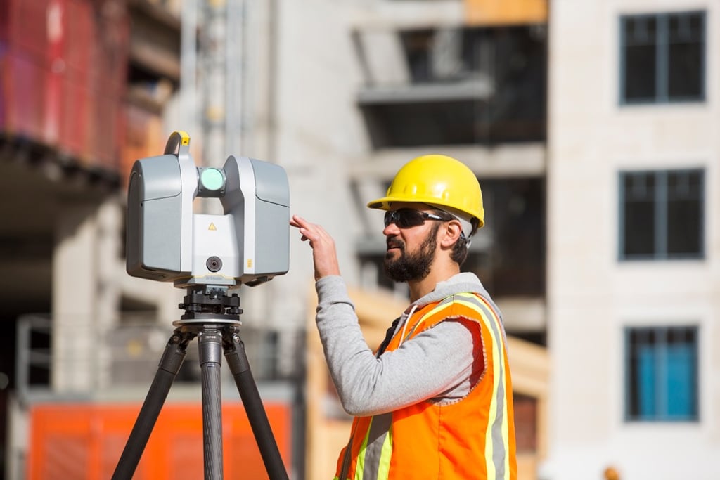
One technology receiving increasing attention is lidar 3d scanning. LiDAR technology provides a method for capturing spatial information from buildings, infrastructure, and project sites.
As projects become more complex, many organisations are exploring digital data capture methods to support project planning and information management throughout the project lifecycle.
What Is LiDAR 3D Scanning?
LiDAR 3D scanning stands for Light Detection and Ranging. It is a surveying and data capture method that uses laser measurements to record information about physical environments.
During the scanning process, laser pulses are directed towards surfaces and objects. Reflected signals are then recorded and processed to create digital representations of the scanned area.
Depending on project requirements, outputs may include:
Point clouds
3D models
Existing condition surveys
Building documentation
Site information records
The type, quality, and usefulness of outputs depend on project objectives, scanning methods, environmental conditions, and data processing workflows.
How LiDAR 3D Scanning Works
LiDAR technology collects a large number of measurements across a site or structure.
These measurements are processed to create a digital representation of the scanned environment.
Data Collection
Scanning equipment records spatial information from surrounding surfaces and objects.
This process may capture information relating to:
Buildings
Infrastructure
Site features
Structural elements
Mechanical systems
The amount and quality of information captured depend on project-specific circumstances.
Point Cloud Creation
Collected measurements are processed into a point cloud.
A point cloud consists of numerous digital data points that represent the physical characteristics of the scanned environment.
Data Processing
The point cloud may be further processed to support project-specific requirements.
Outputs can include digital models, drawings, and information datasets depending on project objectives.
Why LiDAR 3D Scanning Is Used in Construction
Construction projects often require information about existing site conditions.
LiDAR scanning may be used alongside other surveying and documentation methods depending on project requirements.
Site Documentation
LiDAR scanning may assist with capturing information about existing site conditions at a specific point in time.
This information may be used to support project planning and documentation activities.
Design Development
Project teams may use captured site information during design development processes.
The suitability and usefulness of scanned data depend on project requirements and intended applications.
Renovation and Refurbishment Projects
Existing buildings may contain features that are challenging to document using conventional methods alone.
LiDAR scanning may provide a digital record of existing conditions before design or construction activities commence.
Asset Information Management
Digital site information may continue to be referenced after project completion.
Asset owners may use available information to support maintenance planning, operational activities, and future project considerations.
LiDAR 3D Scanning at a Glance
Feature
Description
Laser-Based Data Capture
Uses laser measurements to record spatial information
Point Cloud Generation
Creates digital representations of scanned environments
Existing Condition Surveys
Captures information about buildings and sites
3D Modelling Support
May provide data for digital model development
Construction Applications
Supports planning and documentation activities
Asset Information
May assist with operational and maintenance planning
Digital Records
Provides a record of site conditions at a specific time
Applications of LiDAR 3D Scanning
The use of lidar 3d scanning extends across a range of construction and building projects.
Building Surveys
LiDAR scanning may be used to capture information about existing structures.
This information can support documentation and project planning activities.
Infrastructure Projects
Infrastructure assets may be scanned to collect spatial information for review and analysis.
Project requirements determine how the collected information is used.
Construction Planning
Project teams may use scanned site information to better understand existing site conditions before construction activities begin.
Digital Model Development
Point cloud data may be incorporated into digital modelling workflows where appropriate.
The specific outputs depend on project objectives, software workflows, and technical requirements.
Potential Benefits of LiDAR 3D Scanning
The adoption of lidar 3d scanning continues to increase across various sectors.
Potential benefits vary according to project scope, implementation methods, and project objectives.
Spatial Data Capture
LiDAR technology is designed to capture spatial data from buildings and project sites, subject to equipment capabilities, site conditions, and project requirements.
Digital Information Management
Captured data may be stored and managed within digital project environments.
This may assist with the organisation and management of project information for authorised stakeholders, depending on project systems, permissions, and information management processes.
Documentation Support
LiDAR scanning may assist with creating digital records of existing site conditions.
The effectiveness of documentation processes depends on project-specific circumstances.
Project Coordination
Digital site information may support discussions between project participants during planning and development stages.
Outcomes depend on how information is collected, processed, managed, and applied throughout the project lifecycle.
LiDAR 3D Scanning and Digital Construction
Australia's construction sector continues to explore digital technologies that support information management and project planning.
LiDAR scanning is increasingly incorporated into broader digital construction workflows.
Applications may include:
Existing condition capture
Site documentation
Digital modelling support
Infrastructure assessment
Asset information development
The suitability of LiDAR scanning depends on project objectives, available resources, technical requirements, and stakeholder needs.
Considerations Before Using LiDAR 3D Scanning
Successful implementation requires planning and clearly defined project requirements.
Project Objectives
Organisations should determine how scanned information will be used before commencing data capture activities.
Data Management
Large volumes of information may be generated during scanning projects.
Appropriate data management processes may assist with storage, accessibility, and ongoing use of project information.
Project Requirements
The level of detail required varies between projects.
Scanning methods and deliverables should align with project objectives and information requirements.
The Future of LiDAR 3D Scanning
Digital surveying and data capture technologies continue to evolve.
Future developments may include:
Enhanced data processing workflows
Improved digital integration
Expanded modelling applications
Greater use within digital construction environments
Industry adoption will continue to depend on project requirements, technological developments, and organisational needs.
Conclusion
The growing use of lidar 3d scanning reflects the construction industry's increasing focus on digital information capture and management.
By providing a method for recording existing site and building conditions, LiDAR technology may support planning, documentation, and information management activities across a range of project types.
The quality, completeness, and usefulness of scanned information may be affected by project conditions, site access, environmental factors, equipment settings, scanning methodologies, and data processing methods.
Project outcomes depend on factors including project scope, data quality, stakeholder collaboration, processing methods, and implementation practices. The use of LiDAR 3D scanning does not guarantee specific project outcomes, performance improvements, accuracy levels, or regulatory compliance.
Organisations considering LiDAR scanning should assess their project objectives, information requirements, and operational needs before selecting an appropriate approach.
Frequently Asked Questions
What is LiDAR 3D scanning?
LiDAR 3D scanning is a laser-based data capture method used to record spatial information and create digital representations of buildings, infrastructure, and project sites.
What is a point cloud?
A point cloud is a collection of digital data points generated from scanned measurements. It represents the physical characteristics of a scanned environment.
How is LiDAR 3D scanning used in construction?
It may be used for site documentation, existing condition surveys, project planning, digital modelling support, and asset information management.
Does LiDAR 3D scanning guarantee project accuracy?
No. Data quality and project outcomes depend on factors such as project requirements, environmental conditions, scanning methods, equipment settings, processing workflows, and implementation practices.
Is LiDAR 3D scanning suitable for all projects?
Suitability depends on project objectives, information requirements, budget considerations, technical requirements, and stakeholder needs.
+61 407 923 777
steve@scanbuild.com.au
Newcastle | Hunter | Central Coast | Sydney
© 2026 ScanBuild. All Rights Reserved. | Privacy Policy | Terms & Conditions


Peace of Mind.


REACH US