3D LiDAR Scanner: Improve Accuracy & Reduce Rework
Learn how a 3D LiDAR scanner improves site accuracy, reduces costly rework, supports BIM workflows, and helps construction teams work smarter.

How a 3D LiDAR Scanner Improves Accuracy and Reduces Costly Rework
If you've ever been involved in a construction project, you know how quickly a small measurement error can turn into a major headache. One incorrect dimension, one missed detail, or one outdated drawing can trigger delays, budget overruns, and hours of unnecessary work.
And here's the frustrating part. Most rework isn't caused by poor craftsmanship. It's often caused by inaccurate information from the start.
That's where a 3D LiDAR scanner changes the game.
Instead of relying on manual measurements or incomplete site data, construction, engineering, and architecture teams can capture highly detailed digital representations of existing conditions. The result? Better decisions, fewer surprises, and significantly less rework.
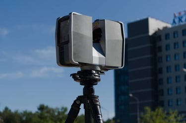
What Is a 3D LiDAR Scanner?
A 3D LiDAR scanner is a technology that uses a LiDAR sensor to measure distances by sending laser pulses and recording how long they take to return after hitting a surface.
Think about standing in the middle of a construction site and capturing millions of measurements in a matter of minutes. That's essentially what happens during LiDAR 3D scanning.
The collected data creates a highly accurate point cloud, which represents the physical environment in digital form. This digital model can then be used for planning, design, analysis, and project coordination.
Why Accuracy Matters in Construction
Construction projects involve countless moving parts. Architects, engineers, contractors, surveyors, and project managers all depend on accurate information to do their jobs effectively.
When measurements are wrong, the consequences can be expensive:
Materials may be ordered incorrectly.
Fabricated components may not fit.
Installation teams may encounter unexpected obstacles.
Design revisions may become necessary.
Project schedules can quickly fall behind.
And that's when rework starts piling up.
Every time a team has to redo completed work, costs increase and productivity drops.
How LiDAR Reduces Costly Rework
One of the biggest causes of rework is working with outdated or incomplete site information.
A 3D LiDAR scanner captures existing conditions with exceptional detail. Instead of relying on assumptions, project teams can work from accurate data collected directly from the site.
Here's what I mean.
Imagine designing around a structural element that was measured incorrectly. By the time the mistake is discovered, multiple project stages may already be affected. Accurate scanning helps prevent those issues before they happen.
Detecting Problems Early
Construction teams often discover conflicts only after installation begins.
But when a site is digitally captured through LiDAR 3D scanning, potential issues become visible much earlier in the process.
Teams can identify:
Space conflicts
Structural inconsistencies
Clearance issues
Design discrepancies
Finding problems before construction starts is almost always cheaper than fixing them later.
Improving Communication Between Teams
A common challenge on construction projects is that different stakeholders may be working from different versions of information.
Accurate scan data creates a single source of truth.
Everyone can reference the same digital representation of the site, reducing misunderstandings and helping teams coordinate more effectively.
Supporting BIM Workflows
The role of BIM in construction industry projects continues to grow as organizations seek better collaboration and project visibility.
Accurate scan data integrates seamlessly into BIM workflows, allowing teams to create models that reflect real-world conditions.
This improves:
Design accuracy
Clash detection
Project planning
Facility management
Construction coordination
Instead of designing based on assumptions, teams can design based on reality.
And that makes a huge difference.
Faster Decision-Making on Site
You know that moment when a project team has to stop work because nobody is completely sure what the site conditions actually are?
Those delays add up.
A 3D LiDAR scanner provides detailed site information that can be reviewed remotely and revisited whenever needed. Teams don't always need to return to the site for additional measurements, which saves both time and money.
Faster access to reliable data often leads to faster decisions and smoother project delivery.
The Growing Role of LiDAR Technology
As construction technology continues to evolve, LiDAR is becoming part of a broader digital ecosystem.
You'll increasingly see discussions around technologies such as digital twins, automation, and even the 3D printer LiDAR scanner combination, where precise site data helps support advanced manufacturing and construction workflows.
While these technologies serve different purposes, they all share one goal: reducing errors and improving project outcomes through better information.
Conclusion
Construction projects are complex enough without having to deal with preventable mistakes. A 3D LiDAR scanner helps eliminate much of the uncertainty that leads to costly rework by providing highly accurate site data from the beginning.
Whether it's improving measurements, supporting BIM workflows, identifying conflicts early, or helping teams make better decisions, LiDAR technology gives construction professionals a clearer picture of reality. And when teams start with accurate information, they can plan better, build faster, and avoid expensive corrections later in the project.
FAQs
1. What is a 3D LiDAR scanner?
A 3D LiDAR scanner uses laser technology to capture precise measurements and create digital representations of physical environments.
2. How does a LiDAR sensor work?
A LiDAR sensor sends laser pulses and measures the time it takes for them to return after hitting an object.
3. What is LiDAR 3D scanning?
LiDAR 3D scanning is the process of collecting millions of spatial measurements to create accurate digital models.
4. How accurate is LiDAR scanning?
Modern LiDAR systems can achieve very high levels of accuracy, often within millimeters depending on the equipment and environment.
5. Why does rework happen in construction?
Rework is commonly caused by inaccurate measurements, design conflicts, communication issues, and incomplete site information.
+61 407 923 777
steve@scanbuild.com.au
Newcastle | Hunter | Central Coast | Sydney
© 2026 ScanBuild. All Rights Reserved. | Privacy Policy | Terms & Conditions

Peace of Mind.
REACH US